October followed a warm September with above average temperatures. Unfortunately, what was below average in October were our rainfall totals.
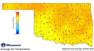
Looking back at October, our average air temperatures for the month were 4 to 7 degrees above average. Northern and central sections of the state, the yellow-orange areas, had the largest departure from the Oklahoma Mesonet Long-term 15-year average (2001-2015).
That moved crops, like cotton and peanut, to harvest-ready maturity. Farmers love harvesting sooner, so no complaints from them. And the yields are looking good for cotton, corn, peanuts, soybeans, and sorghum. Commodity prices are low, so that’s a depressing topic.
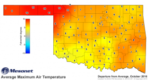
By comparing the maps of maximum and minimum air temperature departures from the departure from average air temperature map, you can see that for most Oklahoma Mesonet locations above average temperatures were driven more by daytime heating in October. The strongest examples are the departure from average maximum air temperatures in the Panhandle. They were 9 to 11 degrees above the long-term 15-year average. The nighttime temperature departures in the Panhandle came in much lower at 2 to 4 degree above average.
Altus was a spot where all the departure temperatures, average, minimum, and maximum, were all 4 degrees above average. So there was equal influence from daytime and nighttime warmer conditions.
The average temperature for Pryor was 7 degrees above average. The departure in maximum temperature was 6 degrees, while the departure in minimum temperature was 8 degrees. At Pryor, nighttime temperatures had slightly more warming influence than the daytime temperatures.
If we’re going to be warmer, plants and animals do better if that is mainly during the day and not at night. Night is a time for plants and animals to recuperate from daytime heating.
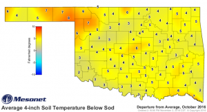
Those warmer air temperatures gave us warmer soil temperatures. For October, the four-inch soil temperature under vegetation ranged from 2 to 8 degrees above the 15-year average.
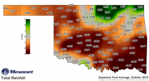
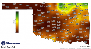
For rainfall, we just didn’t measure up well across most of the state. The dark brown areas were 2 to 4 inches below normal October rainfall. Orange tinged areas were typically closer to one inch below normal rainfall for October. Counties in the green band in the Northeast were the winners in October with 2 to 5 inches above average rainfall.
And here are the Mesonet collected rainfall totals for October 2016.


